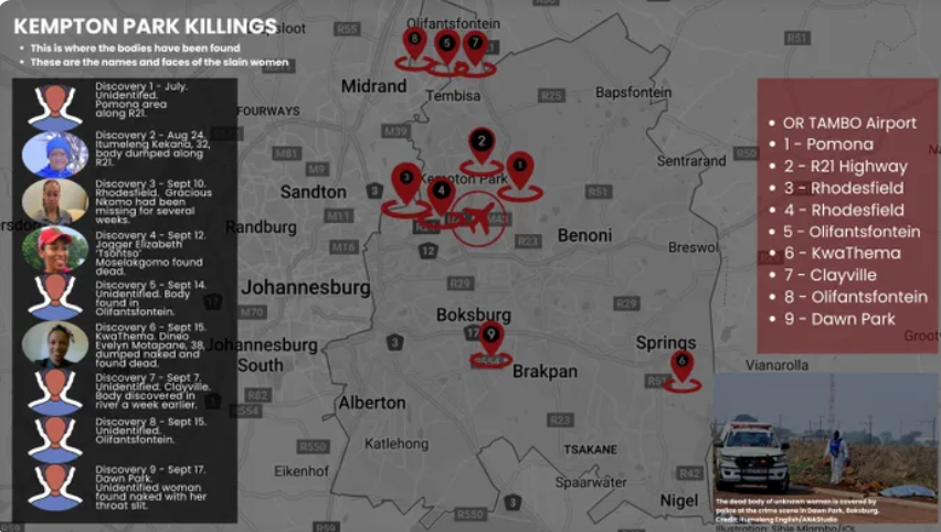
A possible transport-corridor pattern has emerged in the locations where the bodies of nine women were discovered across Ekurhuleni between July and September, prompting fresh questions about how the victims may have been moved before they were found.
The geographical analysis, compiled by security expert Jan Joubert Jooste on 17 September, maps the publicly reported recovery sites and considers whether their distribution could provide investigators with clues about the movements of a possible offender or offenders.
The analysis is not an official South African Police Service document, and it does not identify a suspect. It also does not prove that the nine deaths are connected or that a single person was responsible.
Instead, the report points to a possible transportation geography that began with a concentration around Kempton Park and the R21 before spreading into other parts of the East Rand.
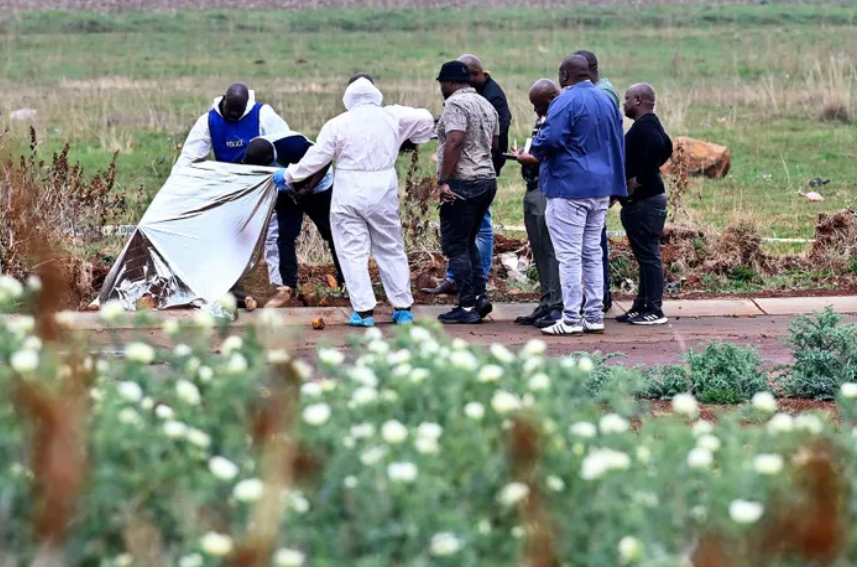
The reported recovery locations include Kempton Park, Pomona, Rhodesfield, Olifantsfontein, KwaThema and Springs, Clayville and Tembisa, and Dawn Park in Boksburg. The ninth body was discovered in Dawn Park on 17 September. Police indicated that the woman appeared to have been killed elsewhere and that her body had been dumped in the area.
Jooste stressed that the findings must be treated with caution. The place where a body is found does not automatically reveal where the victim was killed or where a possible offender lives.
“SAPS has not confirmed that all nine deaths were committed by one offender,” the report states.
The analysis suggests that investigators should consider whether some of the locations are linked by roads and regular travel routes rather than focusing only on one neighbourhood. Jooste said a possible offender could have had familiarity with the wider East Rand road and transport network without necessarily living in Kempton Park.
“Rather than focusing only on where a possible offender lives, investigators could examine whether the person had regular familiarity with the wider East Rand Road and transportation network,” he said.
The distinction is important because a body-disposal site may be chosen for reasons that have nothing to do with the offender’s home. A person may know an area through work, family commitments, social activities or routine travel. A location may also be selected because it is easy to reach, has poor visibility or provides access to connecting roads.
The report warns that a disposal location alone cannot establish an offender’s residence. The recovery sites may reveal where someone felt comfortable travelling, where a vehicle could be parked or where a body could be left, but they do not on their own identify the person responsible.
The condition of some of the bodies could also help investigators establish whether the places where they were found were the original crime scenes.
Police said one woman found near Rhodesfield on 10 September was already in an advanced or decomposed state. Another decomposed body was reported in KwaThema on 15 September.
Jooste said decomposition alone does not prove that a body was moved after death. Temperature, humidity, exposure, clothing and the amount of time since death can all affect how quickly a body decomposes.
However, he said forensic estimates of the time since death could be compared with the period during which each victim could reasonably have been at the recovery site.
“If forensic evidence shows that a victim had been dead for substantially longer than she could have been at the location where her body was found, investigators could consider whether the primary crime scene was elsewhere. This distinction could change the geographical significance of the recovery sites,” he said.
If evidence eventually indicates that a victim was killed somewhere else, investigators would need to reconstruct several stages of her final movements. These could include where she was last seen or encountered, the place where an assault or killing took place, any temporary holding location, the point where she was placed into a vehicle, the route followed and the site where her body was finally left.
Jooste identified four possible explanations for the geographical pattern if the cases are eventually shown to be connected.
The first is that Kempton Park may have been an activity anchor. Repeated discoveries in or near the area could reflect familiarity with the surroundings, although that would not prove that an offender lived there.
The second possibility is wider East Rand mobility. A person may regularly travel through several Ekurhuleni corridors for employment, family responsibilities, social activities or other ordinary reasons.
The third possibility is that the pattern reflects disposal geography rather than offender geography. If victims were killed in other locations and transported to where their bodies were found, the sites could reveal accessible routes and dumping areas instead of a suspect’s home area.
The fourth possibility is that there were multiple offenders or separate perpetrators. Similarities in the victims’ profiles and the geographical closeness of some recovery sites do not, by themselves, prove that one person was responsible for all nine deaths.
The analysis recommends that investigators establish the exact GPS coordinates of every confirmed recovery site. They should also separately identify each victim’s last known location, likely encounter point, possible assault location and disposal site.
The estimated times of death should be compared with the times when the bodies were discovered. The order in which bodies were found does not necessarily show the order in which the women died.
Technology and travel records could provide important leads. Jooste recommends examining closed-circuit television and automatic number plate recognition data along the R21, R24, N12 and connecting roads. Investigators could look for vehicles appearing repeatedly near relevant locations or travelling during time windows linked to the cases.
Lawfully obtained cellphone tower records could also be compared with the relevant periods. Transport nodes, petrol stations, businesses and areas with limited camera coverage may provide additional information about the movement of people and vehicles.
Forensic comparisons could be critical if investigators are trying to determine whether apparently separate scenes are connected. These comparisons could include DNA, fibres, restraints, tool or weapon marks, tyre impressions and other details recovered from the scenes.
Jooste also recommends examining the women’s routines and individual circumstances, rather than relying only on broad details such as age, sex and the places where their bodies were found. Their last movements, contacts, work patterns and travel habits could help investigators establish whether the cases share a connection.
The preliminary analysis does not conclude that an offender lives in Kempton Park, nor does it identify any person as a suspect. Its central finding is that the publicly available information shows a possible movement corridor, beginning near Kempton Park and the R21 before expanding across the wider East Rand.
That theory will need to be tested against verified timelines, forensic evidence, camera footage, vehicle records and telecommunications information. Until that work is done, the locations remain clues rather than proof.
For the families of the nine women, however, the need for answers is immediate. Every recovery site represents a woman whose identity, final movements and death must be fully investigated. Whether the cases are connected or not, police now face the urgent task of establishing the truth behind each one.