

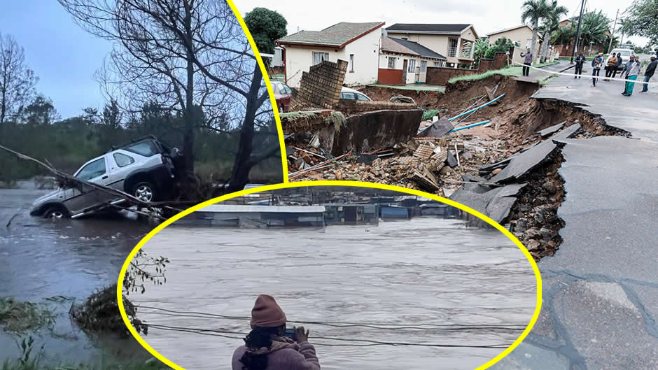
The South African Weather Service (SAWS) has issued a series of high-level impact-based warnings across multiple provinces, signalling another period of potential devastation for a country still reeling from a national disaster declared only months ago. From the escarpments of Mpumalanga to the coastal reaches of KwaZulu-Natal, the atmosphere is once again primed for chaos, with meteorologists pointing to a dangerous combination of severe thunderstorms, heavy downpours, and gale-force winds.
As of Monday, March 23, 2026, a Yellow Level 4 warning is in effect for the south-eastern parts of Mpumalanga and the northern reaches of KwaZulu-Natal. According to the official advisory from SAWS, these areas are at high risk of severe thunderstorms associated with heavy downpours. The weather service cautioned that these conditions "may result in flooding of susceptible low-lying bridges and roads, as well as damages to infrastructure and settlements, due to strong gusty winds".
The reach of this weather system is vast, extending far beyond the primary alert zones. A Yellow Level 2 warning has also been activated, covering a massive swathe of the interior. This includes southern Gauteng, the southern parts and escarpment areas of Mpumalanga, southern KwaZulu-Natal, the central and eastern parts of the Northern Cape, the Free State, and significant portions of the North West. In these regions, the primary concerns remain localised flooding and potential structural damage to both formal and informal settlements.
|
Province
|
Warning Level
|
Primary Risks
|
Specific Areas Affected
|
|
Mpumalanga
|
Yellow Level 4 & 2
|
Flooding, infrastructure damage, gusty winds
|
South-eastern parts, escarpment, southern regions
|
|
KwaZulu-Natal
|
Yellow Level 4 & 2
|
Heavy downpours, bridge flooding, settlement damage
|
Northern and southern parts
|
|
Gauteng
|
Yellow Level 2
|
Localised flooding, thunderstorm activity
|
Southern parts (excluding City of Tshwane)
|
|
Northern Cape
|
Yellow Level 2 & Fire
|
Flooding, extremely high fire danger
|
Central/eastern parts, Kai !Garib Municipality
|
|
Free State
|
Yellow Level 2
|
Severe thunderstorms, road flooding
|
Widespread central areas
|
|
North West
|
Yellow Level 2
|
Infrastructure damage, heavy rain
|
Vast parts of the province
|
The timing of these warnings is particularly poignant. South Africa is currently navigating a brutal cycle of extreme weather that has tested the nation's resilience to its limits. In January 2026, the government was forced to declare a national disaster following torrential rains and flooding that claimed at least 30 lives and displaced thousands. That crisis, which began in late 2025 and continued into 2026, saw entire communities washed away, with infrastructure damage estimated in the hundreds of millions of rands.
"The South African Weather Service (SAWS) has issued another severe storm warning for several parts of the country," a statement from the organisation noted earlier today. The repetitive nature of these alerts has become a grim feature of the South African calendar. Only on New Year's Day 2026, two tornadoes tore through Mpumalanga, leaving a trail of destruction that many families are still struggling to repair. The January 1st event was a stark reminder of the volatile nature of the highveld's summer storms, which SAWS had accurately predicted with warnings of damaging winds and large hail.
The human cost of these events is most visible in the country's informal settlements. A report released by Amnesty International in November 2025 highlighted how the South African government is failing millions of people trapped in these vulnerable areas, which are often the first to be hit by rising floodwaters. In these communities, a Yellow Level 2 warning is not merely a meteorological update; it is a direct threat to survival. When "heavy downpours result in localised flooding of susceptible low-lying bridges and roads," as SAWS warns, it often means that children cannot reach school, and workers are cut off from their livelihoods.
While much of the country prepares for rain, the Northern Cape faces a different kind of peril. In the Kai !Garib Municipality, SAWS has warned of "extremely high fire danger conditions". The paradox of the South African climate is on full display this week, as the Namakwa District and parts of the Western Cape—including the West Coast, Cape Winelands, Cape Metropole, and Overberg—brace for "very hot and uncomfortable conditions" through Tuesday.
"Very hot and uncomfortable conditions are expected and possible in places over the Namakwa District of the Northern Cape on Monday persisting into Tuesday, when it will include the West Coast district, the Cape Winelands, Cape Metropole, and Overberg local municipalities of the Western Cape," the SAWS advisory stated.
This duality of fire and flood is increasingly being linked to human-driven climate change. A rapid analysis of the floods that occurred between December 2025 and January 2026 found that the intensity of the rainfall was significantly amplified by global warming. Researchers from various international climate organisations have noted that Southern Africa is becoming a hotspot for extreme weather variability. The June 2025 floods in Cape Town, which saw a rare combination of torrential rain, heavy winds, and snow, further underscored this trend, causing dozens of deaths.
For the residents of KwaZulu-Natal, the memory of the catastrophic April 2022 floods remains a fresh wound. Those floods, which killed nearly 450 people, set a precedent for the scale of destruction that modern South African infrastructure must now withstand. The current warnings for northern and southern KZN bring back the same fears of "widespread showers and thundershowers" that can turn small streams into raging torrents within minutes.
The logistical challenge for emergency services is immense. With warnings spread across nearly every province, resources are stretched thin. In Gauteng, the focus remains on the southern parts of the province, though the City of Tshwane has been excluded from the most recent severe thunderstorm alerts. Nevertheless, the South African Weather Service has urged all residents to remain vigilant. "Monday, 23 March 2026: Scattered to widespread thundershowers across most parts of South Africa, with SAWS warnings for severe thunderstorms," read a social media update from a regional weather monitoring group, echoing the official sentiment.
The economic impact of these recurring disasters cannot be overstated. Each time a bridge is washed away in Mpumalanga or a road is flooded in the Free State, the cost of repair adds to a growing national debt. A 2025 study on water infrastructure resilience in South Africa pointed out that the country's aging systems were never designed to handle the frequency of Level 4 events now being recorded. The report argued that "enhancing water infrastructure resilience in response to climate change" is no longer an option but a necessity for national security.
As the sun sets on Monday, the clouds over the eastern escarpment continue to darken. The "strong gusty winds" predicted by SAWS have already begun to rattle windows in the high-lying areas of Mpumalanga. For many South Africans, the night will be spent listening to the rain on corrugated iron roofs, wondering if the foundations of their homes will hold until morning.
The South African Weather Service remains the primary line of defence in this ongoing battle against the elements. Their impact-based warning system, which categorises alerts from Level 1 to Level 10 based on both the probability and the potential severity of the weather, has been credited with saving lives by providing clear, actionable information. However, as the events of the past two years have shown, warnings alone are not enough to protect a population living on the edge of environmental catastrophe.
The story of South Africa's weather in 2026 is one of constant vigilance. From the "Yellow Level 2 warning for severe thunderstorms resulting in heavy downpours" in the North West to the heat advisories in the Western Cape, the nation is caught in a pincer movement of climatic extremes. As the investigative journalist's lens pans across the provinces, the picture that emerges is one of a country in a permanent state of recovery, always looking at the horizon for the next storm.
|
Recent Weather Milestone
|
Date
|
Impact
|
|
National Disaster Declaration
|
January 2026
|
30+ deaths, thousands displaced by floods
|
|
Mpumalanga Tornadoes
|
1 January 2026
|
Two tornadoes, significant structural damage
|
|
Western Cape Winter Floods
|
June 2025
|
Dozens of deaths, heavy snow and rain
|
|
KZN Catastrophic Flooding
|
April 2022
|
~450 deaths, massive infrastructure loss
|
In the coming days, the focus will shift from prediction to response. The "localised flooding of susceptible low-lying bridges and roads" will inevitably lead to traffic disruptions and emergency call-outs. The "extremely high fire danger" in the Northern Cape will require fire-fighting teams to be on high alert. And as the "very hot and uncomfortable conditions" persist in the south-west, the risk of heatstroke and dehydration will become a primary concern for the elderly and vulnerable.
The warnings are clear, the data is unequivocal, and the history is written in the debris of previous storms. South Africa stands once again at the mercy of the skies, waiting to see what the next 24 hours will bring to its battered provinces.