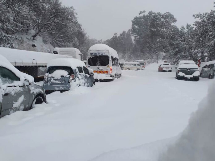
South Africans are bracing themselves for an intense blast of winter weather as eight out of nine provinces prepare to experience snowfall over the coming days. The South African Weather Service (SAWS) has issued a warning about a powerful Cut-Off Low (COL) system that is forecast to bring extreme conditions to every province except Limpopo, starting Saturday, 7 June 2025.
According to SAWS, the system will initially impact the Western and Northern Cape before sweeping eastward across the country early next week. By Monday and Tuesday, it will be affecting the central and eastern provinces, bringing a dramatic drop in temperatures and a range of hazardous weather events.
Vox Weather forecaster Michelle du Plessis has provided a detailed breakdown of what to expect. "This front is supported by a strong upper-air trough, helping to deepen the system," she explained. "Then on Monday, a cut-off low-pressure system is expected to develop behind the front, with freezing levels dropping significantly across the country and snow expected to fall in eight of South Africa’s nine provinces."
Daytime temperatures are expected to plunge significantly, struggling to rise above 10°C in many areas, with icy winds intensifying the chill. Snowfalls are anticipated in nearly every province, sparing only Limpopo, with some areas likely to experience disruptive accumulations.
These snowy conditions are expected to affect major routes, including the N3 highway at Van Reenen’s Pass, potentially leading to road closures or hazardous driving conditions on Monday and Tuesday.
Here's a province-by-province breakdown of what to expect:
Western Cape
The strong cold front is expected to arrive in the Cape early on Saturday morning, bringing heavy rain to the western parts of the province, as well as cold, wet, and windy weather across much of the Cape Provinces. Light snow is expected late on Saturday and overnight into Sunday morning around the Cederberg mountains.
Northern Cape
Light snow is expected late on Saturday and into Sunday morning around the Nuweveld and Roggeveld mountains. On Sunday, light snow will spread over the high-lying regions in the Karoo — including around Loxton, Nieu-Bethesda and Noupoort.
Eastern Cape
All models indicate the likelihood of snow over the northern highlands, but they differ in their expected snowfall amounts. "The GFS model suggests heavier snow, while the ECMWF shows significantly less. More snow is likely in Lesotho," said du Plessis. Snow is expected in Barkly East and the Southern Drakensberg
Free State
A very light dusting of snow is possible over the eastern regions. More snow is expected in regions bordering Lesotho.
KwaZulu-Natal
Underberg and western mountainous areas are expected to experience heavy snowfall on Monday, with extremely low temperatures. Heavy snow is expected around Sani Pass and high mountains, as well as in regions bordering Lesotho and the Southern Drakensberg.
Gauteng
Light snow remains a possibility over the southern parts of Gauteng on Monday, but only the ECMWF model is currently showing this. "As we’ve seen many times before, cut-off lows are unpredictable, and the forecast can change quickly from day to day," du Plessis cautioned. "This means snowfall over Gauteng and nearby areas is still highly uncertain, and it may disappear from the forecast entirely or shift to a chance of freezing rain instead."
Mpumalanga
Similar to Gauteng, light snow is possible over the southern Highveld on Monday, but this is also model-dependent and uncertain.
Lesotho
Heavy snow is expected around Sani Pass and high mountains.
Limpopo
No snow is mentioned or expected in this province.
The storm system is also expected to generate strong and damaging winds over large parts of the interior starting Sunday. These winds could trigger wildfires, especially in the central and eastern regions, ahead of the arrival of colder air.
Along the coasts, gale-force winds and rough seas will develop from Friday on the south-west coast, moving along the southern and eastern shores through the weekend and continuing until at least Tuesday.
Heavy rainfall is forecast for parts of the Eastern Cape coast and nearby inland areas on Sunday, raising the risk of localised flooding and damage to infrastructure. On Monday, the rain is expected to shift toward southern KwaZulu-Natal.
In addition, severe thunderstorms are likely on Monday and Tuesday in provinces such as North West, Gauteng, Mpumalanga, and KwaZulu-Natal, possibly bringing hail and damaging winds.
Farmers with small livestock are urged to take protective measures as the cold and wind seriously threaten animal welfare.
These severe conditions are expected to persist in the eastern parts of the country until at least Wednesday. SAWS has warned the public to prepare for prolonged exposure to bitterly cold weather, strong winds, and dangerous travel conditions in many areas.
Karen Rimmer, Head of Distribution at PSG Insure, has previously cautioned homeowners to take immediate steps to secure their properties. She stressed the importance of outdoor maintenance, highlighting that loose furniture, poorly maintained structures, or neglected items can become hazardous during high winds or storms.
"Homeowners should check that outdoor items are properly fastened and that features like awnings or sheds are in good repair," Rimmer advised. She also recommended trimming back dead plants, branches, and shrubs to reduce the risk of fires, especially during storms when lightning or electrical faults can ignite dry materials. "With winds capable of fanning even small embers, such fire hazards should not be overlooked."
On the financial side, Rimmer recommended that homeowners review their insurance policies to ensure that their coverage accurately reflects the current replacement value of their property. This includes accounting for any special features, finishes, or custom-built elements that may require higher-value coverage in the event of damage.
South Africans are urged to stay informed about weather updates and heed the warnings issued by authorities to ensure their safety during this period of extreme weather.


